61
Reference
Main Menu:
GPS Tab
Pacifi c Ocean, in a geo-stationary orbit over the equator. Effective use of the WAAS satellite signal may
be limited by your geographic location in relation to those satellites, now in developmental service.
WAAS satellite signal reception requires an absolute clear view of the sky and works best when there
are no nearby obstructions such as buildings, mountains, etc.. WAAs satellites will be numbered 33 or
higher when viewing the sky view on your GPS 152. Initial reception of the WAAS signal may take up
to 15-20 minutes, then 1-2 minutes afterwards. When WAAS differential correction has been received
for GPS satellites (numbers 32 or below), a ‘D’ will appear in the signal bar of the sky view and ‘2D
or 3D Diff Navigation’ will appear in the receiver status. To learn more about the WAAS system, its
satellite positions and current state of development, visit the FAA web site (http://gps.faa.gov). Since
WAAS requires CPU resources of the GPS 152 to search for and track the satellites, you may disable the
WAAS feature to improve unit performance if WAAS reception is not available in your area.
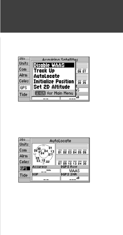
To Disable/Enable WAAS capability
1. From the GPS tab, press MENU, then use the ARROW KEYPAD to highlight ‘Disable WAAS’ or
‘Enable WAAS’ and press ENTER/MARK.
Receiver Status, Accuracy and DOP
Receiver status is indicated at the top fi eld of the page, with the current Accuracy and Dilution Of
Precision (DOP) below the sky view. DOP is an indication of satellite geometry quality measured on a
scale of one to ten (lowest numbers the best, highest numbers the poorest). Accuracy uses DOP and
other factors to calculate horizontal position accuracy in feet or meters. The status fi eld will show one
of the following conditions:
• Looking For Satellites— the receiver is looking for any satellites.
• AutoLocate— the receiver is looking for any satellite whose almanac has been collected. This
process can take up to fi ve minutes.
• Acquiring Satellites— the receiver is looking for and collecting data from satellites visible at its last
known or initialized position, but has not collected enough data to calculate a fi x.
• 2D Navigation— at least three satellites with good geometry have been acquired and a 2 dimensional
GPS Tab Menu Options
Autolocate Mode