


Chapter 6: Further Chart Operations 6-1
Introduction
Chapter 6: Further Chart Operations
6.1 Introduction
This chapter explains how to use the additional functions that are provided on
the
hsb
2
series chartplotter and combined radar/chartplotter.
It covers the following topics:
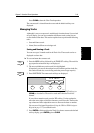
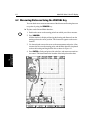
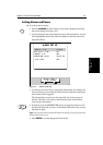
• Measuring distances and bearings on the chart, using the
VRM/EBL key
• Setting alarms and timers
• Man Overboard (MOB)
• Cursor Echo
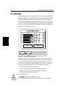
• GPS Setup
• Data Log Mode
In order to use some of these functions, you may need the following additional
data from equipment connected to your system via a
hsb
2
, SeaTalk, or NMEA
link:
*If heading data is available via both NMEA and SeaTalk, NMEA data takes priority. For all other data,
SeaTalk data takes priority (see ).
Table 6-1: Function of External Data
Data Example source Integrated functions available
Heading
COG
Compass*
GPS
- Head Up or Course Up heading modes
- MOB (if speed data also available)
- Radar/Chart Overlay
Radar data Radar system, via
either a
combined unit or
hsb
2
- Radar data, either full-screen or in a half-screen window
- Radar/Chart Overlay
Position GPS system - Waypoints
- Position, COG, SOG and time data in Data Box and Nav
Window
- MOB
- Radar/Chart Overlay
- Data Log
Other data Transducers - Data Box and Nav Window data displays, including speed,
depth, wind, temperature