


8-24
hsb
2
PLUS Series Color LCD Display
SeaTalk® and NMEA
In
SeaTalk
®
and NMEA In
The
hsb
2
series display can receive a comprehensive range of data. The
primary data is described below:
*Accurate heading data is required for MARPA and radar/chart overlay, and it
must be provided on NMEA. We recommend the Raymarine Rate Gyro
Compass or a Raymarine autopilot system incorporating a 150G or 400G
Course Computer with internal rate gyro.
Heading data should ideally contain both magnetic and true heading. If only
one is available then variation needs to be provided either manually or
automatically - see Variation Source on page 7-8.
Some other radars and chartplotters can exchange their cursors via SeaTalk.
Locked heading should be used for Course Up if available via SeaTalk.
Other data connected via a SeaTalk bus or via NMEA is generally displayed in
data boxes, e.g. depth, apparent wind angle and speed, time.
Note: The Fishfinder uses its own depth data, rather than any other depth data
on SeaTalk. If there is no other depth data on SeaTalk, Fishfinder depth is
transmitted. If speed and temperature data are available on SeaTalk the Fish-
finder uses this data; if this data is not on SeaTalk from other instruments, it is
transmitted by the Fishfinder.
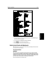
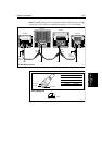
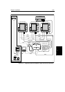
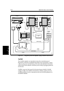
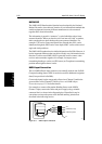
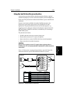
For details of received data refer to the table in Appendix D:SeaTalk and
NMEA Data Received and Transmitted. Examples of SeaTalk and NMEA
systems are shown in Figure 8-14 and Figure 8-15.
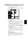
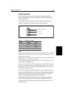
Table 8-4: Function of SeaTalk and NMEA Data
Data Primary Uses Suggested Source
Heading Heading Modes
MOB (if Speed data also available)
Radar/Chart Overlay (chart),
MARPA (radar)
Autopilot,
Compass connected to SeaTalk bus
NMEA Compass*
Position MOB (also requires speed and HDG
data)
Radar/Chart Overlay
Position data in data box and Nav
Window
Waypoints & Marks
Own vessel position (chart)
Data Log (chart)
SeaTalk GPS connected via Auxiliary JB
Existing GPS Navigator via SeaTalk bus
Existing GPS (or Loran-C) navigator with
NMEA output
Waypoint Chart: Waypoint and route transfer Existing GPS Navigator via SeaTalk bus
Existing GPS (or Loran-C) navigator with
NMEA output