


16 EuroPak-15a Receiver User Manual Rev 5
Chapter 1 Introduction
This chapter provides information on the features and functionality of the EuroPak-15a and how it operates in
the context of an SBAS system.
1.1 Overview of the EuroPak-15a
The EuroPak-15a is a high-performance GPS, Galileo and GEO receiver capable of receiving and tracking
sixteen GPS L1, GPS L5, Galileo L1 and Galileo E5a signals. Alternatively, four of the sixteen signals can be
SBAS GEO L1 and SBAS GEO L5 signals. The EuroPak-15a also decodes the navigation signals.
There is flexibility in areas such as configuration and specification of output data and control signals. Multiple
software models are available, allowing you to better fit the receiver to the application while maintaining the
option for a compatible upgrade path.
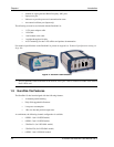
The EuroPak-15a enclosure offers a complete solution, a protective enclosure that provides an interface to the
receiver card’s power, data, and status signals.
1.2 SBAS Overview
A Satellite-Based Augmentation System (SBAS) is a safety-critical system designed to augment the
Department of Defense Global Positioning System (GPS) Standard Positioning Service (SPS). SBAS enhances
GPS service by providing:
• a ranging function to the SBAS satellites, which improves signal availability and reliability
• GPS signal corrections, which improve accuracy
• integrity monitoring, which improves safety
The primary mission of the SBAS system is to provide a means for air navigation for all phases of flight in the
National Airspace System (NAS) from departure, through en route, and approach. The principal functions of
SBAS include:
• determining ionospheric corrections
• determining satellite orbits
• determining satellite clock corrections
• determining satellite integrity
• independent data verification
• SBAS message broadcast and ranging
• system operations & maintenance
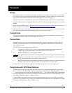
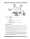
As shown in Figure 1 on Page 17, the SBAS system consists of a series of Reference Stations and Master
Stations, a Ground Uplink Subsystem, and Geostationary Satellites (GEOs). The Reference Stations, which are
strategically located to provide adequate coverage, pick up GPS satellite data and route it to the Master
Stations. The Master Stations then process the data to determine the signal integrity, signal corrections, and
residual errors for each monitored satellite. This information is sent to the Ground Uplink Subsystem for
transmission to the GEOs, which then re-transmits the data on the GPS L1 and L5 (not yet available)
frequency. In the future, the system will support L5 signal frequency broadcasts.