


SPAN-CPT User Manual Rev 8 11
Chapter 1 Introduction
NovAtel's SPAN
®
(Synchronized Position Attitude Navigation) technology brings together two different
but complementary positioning and navigation systems: GNSS and an Inertial Navigation System (INS).
By combining the best aspects of GNSS and INS into one system, SPAN technology offers a solution that
is more accurate and reliable than either GNSS or INS alone. The combined GNSS+INS solution has the
advantage of the absolute accuracy available from GNSS and the continuity of INS through traditionally
difficult GNSS conditions.
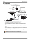
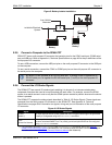
SPAN-CPT combines GNSS and Inertial Measurement Unit (IMU) hardware inside a single enclosure for
simple installation and operation. NovAtel’s OEM6
®
receiver is the processing engine of SPAN-CPT and
the IMU components are manufactured by KVH Industries. Commercial components are used in
SPAN-CPT to offer the same benefits of other SPAN products, but with fewer export restrictions.
1.1 Fundamentals of GNSS+INS
GNSS positioning observes range measurements from orbiting Global Positioning System Satellites.
From these observations, the receiver computes position and velocity with high accuracy. NovAtel GNSS
positioning systems are highly accurate positioning tools. GNSS, however, does have some significant
restrictions which limit its usefulness in some situations. GNSS positioning requires line of site view to at
least four satellites simultaneously. If this criteria is met, differential GNSS positioning can be accurate to
within a few centimetres. If however, some or all the satellite signals are blocked, the accuracy of the
position reported by GNSS degrades substantially or may not be available at all.
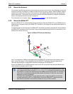
An INS uses forces and rotations measured by an IMU to calculate position, velocity and attitude. This
capability is embedded in the firmware of the SPAN-CPT. Forces are measured by accelerometers in
three perpendicular axes within the IMU and the gyros measure angular rotation rates around those
axes. Over short periods of time, inertial navigation gives very accurate acceleration, velocity and attitude
output. The INS must have prior knowledge of its initial position, initial velocity, initial attitude, Earth
rotation rate and gravity field. Since the IMU measures changes in orientation and acceleration, the INS
determines changes in position and attitude, but initial values for these parameters must be provided
from an external source. Once these parameters are known, an INS is capable of providing an
autonomous solution with no external inputs. However, because of errors in the IMU measurements that
accumulate over time, an inertial only solution degrades with time unless external updates such as
position, velocity or attitude are supplied.
The SPAN-CPT system’s combined GNSS+INS solution integrates the raw inertial measurements with
all available GNSS information to provide the optimum solution possible in any situation. By using the
high accuracy GNSS solution, IMU errors can be modeled and mitigated. Conversely, the continuity and
relative accuracy of the INS solution enables faster GNSS signal reacquisition and Real Time Kinematic
(RTK) solution convergence.
The advantages of using SPAN-CPT technology are its ability to:
• Provide a full attitude solution (roll, pitch and azimuth)
• Provide continuous solution output (in situations when a GNSS-only solution is impossible)
• Provide faster signal reacquisition and RTK solution resolution (over stand alone GNSS because
of the tightly integrated GNSS and INS filters)
• Output high rate (up to 100 Hz) position, velocity and attitude solutions for high dynamic
applications, see also Logging Restriction on page 33.
• Use raw phase observation data (to constrain INS solution drift even when too few satellites are
available for a full GNSS solution)