


Garmin GPSMAP 695/696 Owner’s Manual
190-00919-00 Rev. F
115
Hazard Avoidance
Overview GPS Navigation Flight Planning Hazard Avoidance Additional Features Appendices Index
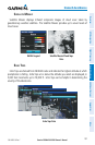
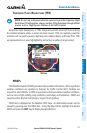
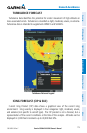
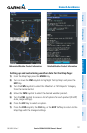
TURBULENCE FORECAST
Turbulence data identifies the potential for erratic movement of high-altitude air
mass associated winds. Turbulence is classified as light, moderate, severe, or extreme.
Turbulence data is intended to supplement AIRMETs and SIGMETs.
Turbulence Data and Legend
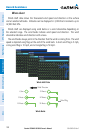
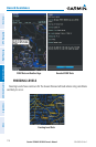
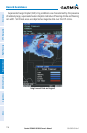
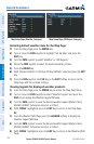
ICING FORECAST (CIP & SLD)
Current Icing Product (CIP) data shows a graphical view of the current icing
environment. Icing severity is displayed in four categories: light, moderate, severe,
and extreme (not specific to aircraft type). The CIP product is not a forecast, but a
representation of the current conditions at the time of the analysis. Altitudes can be
displayed in 3,000-foot increments up to 30,000 feet MSL.