


Garmin GPSMAP 695/696 Owner’s Manual
190-00919-00 Rev. F
133
Hazard Avoidance
Overview GPS Navigation Flight Planning Hazard Avoidance Additional Features Appendices Index
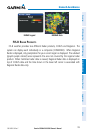
METARS AND TAFS
NOTE:
METAR information is only displayed within the installed navigation
database service area.
METAR (METeorological Aerodrome Report) is an international code used for
reporting weather observations. METARs are updated hourly or as needed. METARs
typically contain information about the temperature, dewpoint, wind, precipitation,
cloud cover, cloud heights, visibility, and barometric pressure. They can also contain
information on precipitation amounts, lightning, and other critical data. If METAR data
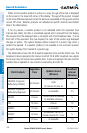
is available for an airport, a color-coded flag is shown next to the airport.
TAF (Terminal Area Forecast) is the standard format for 24-hour weather forecasts.
TAFs may contain some of the same code as METAR data. It typically forecasts
significant weather changes, temporary changes, probable changes, and expected
changes in weather conditions.
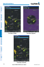
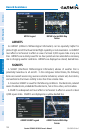
METAR and TAF text data is displayed on the Map Page and the Weather (WX) Page.
An abbreviated version can be viewed by panning over the METAR flag. Pressing the
ENT Key will display additional information. METAR and TAF data can be displayed as
raw or decoded text.
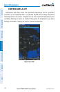
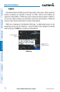
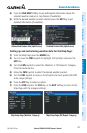
Changing METAR and TAF text:
1)
Using the Map Pointer, select the desired METAR and press the ENT Key; or
from the Waypoint (WPT) Page press the WEATHER Softkey. The Weather
Information Page is displayed.
2)
Press the MENU Key.
a)
Select ‘Show Decoded Text’ or ‘Show Raw Text’.
b)
Press the ENT Key.
Or
:
a)
Select ‘Change Text Size’ and press the ENT Key.
b)
Select ‘Small’, ‘Medium’, or ‘Large’ and press the ENT Key.
The METAR flag color is determined by the information in the METAR text.