


Garmin GPSMAP 695/696 Owner’s Manual
190-00919-00 Rev. F
142
Hazard Avoidance
OverviewGPS NavigationFlight PlanningHazard AvoidanceAdditional FeaturesAppendicesIndex
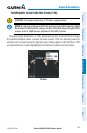
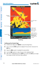
4.2 TERRAIN
WARNING:
Do not use Terrain information for primary terrain avoidance.
Terrain information is intended only to enhance situational awareness.
NOTE:
Terrain data is not displayed when the aircraft is outside the installed
terrain database coverage area.
NOTE:
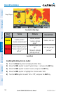
Terrain depicted in the Profile View is always “ahead” of the aircraft,
and will change as ground track changes.
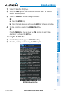
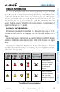
The Terrain Page displays altitudes of terrain and obstructions relative to the aircraft
position and altitude with reference to a database that may contain inaccuracies.
Terrain and obstructions are shown only if they are in the database. Terrain and
obstacle information should be used as an aid to situational awareness. They should
never be used to navigate or maneuver around terrain.
Note that all obstructions may not be available in the terrain and obstacle database.
No terrain and obstacle information is shown without a valid 3-D GPS position.
The GPSMAP 695/696 GPS receiver provides the horizontal position and altitude of
the aircraft. Aircraft GPS altitude is derived from satellite position. GPS altitude is then
converted to a mean sea level (MSL)-based altitude (GPS-MSL altitude) and is used to
determine terrain and obstacle proximity. GPS-MSL altitude accuracy is affected by
satellite geometry, but is not subject to variations in pressure and temperature that
normally affect pressure altitude sensors. GPS-MSL altitude does not require local
altimeter settings to determine MSL altitude. It is a widely-used MSL altitude source.
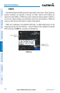
Terrain and obstacle databases are referenced to MSL. Using the GPS position
and altitude, the Terrain feature portrays a 2-D picture of the surrounding terrain and
obstacles relative to the position and altitude of the aircraft. GPS position and GPS-
MSL altitude are used to calculate and predict the aircraft’s flight path in relation to the
surrounding terrain and obstacles. In this way, the pilot can view predicted dangerous
terrain and obstacle conditions.
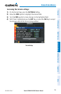
Alert windows appear on all pages (except the Terrain (TER) Page) to inform the
pilot of proximity to the terrain and obstacles, as well as an unsafe descent rate. These
alerts depend on user-defined parameters in the Terrain Page setup.