


Garmin GPSMAP 695/696 Owner’s Manual
190-00919-00 Rev. F
119
Hazard Avoidance
Overview GPS Navigation Flight Planning Hazard Avoidance Additional Features Appendices Index
USING SiriUsXM WEATHER PRODUCTS
WARNING: Do not use data link weather information for maneuvering in,
near, or around areas of hazardous weather. Information contained within
data link weather products may not accurately depict current weather
conditions.
WARNING: Do not use the indicated data link weather product age to
determine the age of the weather information shown by the data link weather
product. Due to time delays inherent in gathering and processing weather
data for data link transmission, the weather information shown by the data
link weather product may be significantly older than the indicated weather
product age.
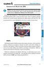
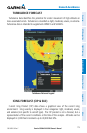
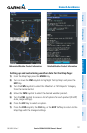
SiriusXM Weather Products can be displayed on the Map Page and individually on
the Weather (WX) Page.
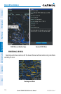
The setup menu for the Navigation Map controls the map range settings above
which weather products are decluttered from the display. If a map range larger
than the weather product map range setting is selected, the weather product data is
removed from the map. For weather products such as METAR, Lightning, and Storm
Cells, the weather product is displayed when a map range “smaller” than the weather
product map range setting is selected (Satellite Mosaic works inversely). The menu
also provides a means for enabling/disabling display of ‘Airmets’, ‘Sigmets’, ‘Weather
Data’, ‘NEXRAD’, and/or ‘Fronts’ on the Navigation Map.
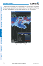
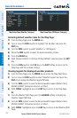
Additional information about the following can be displayed by panning over the
display on the map:
•StormCells
•SIGMETs
•AIRMETs
•METARs
•TFRs