


DSM 132/132RS Receiver User Guide 129
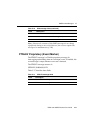
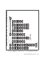
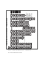
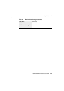
Figure D.6 Navigation map for DSM 132 receiver — Home, Field Operations, and Status
menu
Home
Field
Operations
3
Display
Options
1
Contrast
Lock
Display
Language
Units
Clear
Memory
Exit
1
1
1
2
1
12
2
1
12
2
2
1
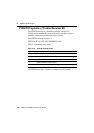
Log Ops
(RDL)
File
Status
Logging
Open/Close
Read RDL
Names List
Client
Name
Farm
Name
Crop
Name
Material
Name
Rate
Note #2
Exit
1
1
1
2
2
2
1
1
2
2
12
1
1
2
2
2
2
1
1
1
Note #1
3
3
Configuration
1
UTC Date
GPS Week
Serial
Number
Firmware
Version
Receiver
Options
System
Voltages
Incident
Code
Exit
Receiver
Status
3
CAN
Status
J1939 Addr
Claim
TPCAN
Chan B
ChB TPCAN
conns
Exit
1
112
12
1212
12
12
12
1
12
12
3
UTC
Time/Day
Status
3
GPS
Status
Lat/Long
Altitude
Speed
Heading
Channel
Status 1-12
DOPs
Exit
1
12
12
12
12
12
1
See Next Page
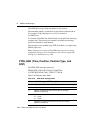
3
Sat. Freq.
Status
Service ID
Provider
DGPS Data
Source
Age of
DGPS/Sync
Thales Svc
Info
Svc Info
Svc ID / IV
Exit
12
12
12
12
12
12
12
DGPS
Status
1
Beacon
Channel 0
1
Beacon
Channel 1
12
DGPS Data
Source
12
Age of
DGPS/Sync
12
Exit
3
Guidance
Ops
Guidance
Status
Set Point A
Set Point B
Set Point C
Change
Swath #
Pause
Add
Headland Pts
Reset
Guidance
1
1
1
2
2
2
12
12
1
12
2
1
Exit
2
2
Info
File
2
1
Utilities
Add Area
Points
Adjusted
Area
Path
Length
Perimeter
Length
Segment
Length
Exit
1
1
1
2
2
1
1
2
2
2
2
2
22
3
22
2
2
Update
Receiver
2
Guidence UI
12
2
ChA TPCAN
conns
Exit
12
2
OmniSTAR
12
Available only when
guidance is enabled
Not used in Marine
D0.1 Navigation map for DSM 132 Receiver — Home, Field Operations, and Status