26
Navigation System
QWERTZ (German) and AZERTY (French)
keyboards. To switch to your desired
QWERTY-type keyboard, press the Keys
button repeatedly until the appropriate
keyboard appears.
The numeric keyboard only contains num-
bers, on huge buttons. The special keys
you fi nd on the other keyboards (except
Space) are available here as well.
Although QWERTY-type keyboards also
contain number keys, when entering a
house number, the program offers the
more convenient numeric keypad.
Discovering the program through the
screens
The best way to discover Cydle is to ex-
plore each screen in detail, and to fi nd out
how to move from one to another. Read
this chapter for a guided tour.
Main menu
Cydle starts by displaying the Main menu.
This is the root of the screen hierarchy, but
you need
to return here very rarely while using the
program. Screens are also accessible from
each other
to reduce the number of actions needed to
initiate a function or change a setting.
Most parts of the program are directly ac-
cessible from here by using the buttons
described below.
About screen
Touch About on the Main menu screen to
open this screen. The About screen is not
used in normal navigation. It is there to in-
form you about the map licenses you have,
the creators of Cydle and the legal aspects
of using the program.
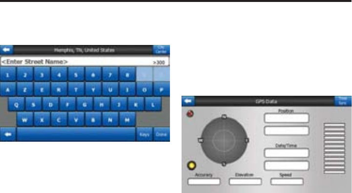
GPS Data screen
Touch the small satellite dish icon on the
Main menu, Map or Cockpit screen to open
this window.
The GPS Data screen is a collection of in-
formation received from the GPS device
and it also serves as the entry point to the
following screens.
GPS Data Display
The virtual sky on the left represents the
currently visible part of the sky above you,
with your position as the center. The satel-
lites are shown at their current positions.
The GPS receives data from both the green
and grey satellites. Signals from the grey
satellites are only received, while green
ones are used by the GPS to calculate your
current location. On the right you can see
the satellite signal strength bars. Dark bars
are for the grey and orange bars are for the
green satellites. To identify satellites use
their numbers also shown in the virtual sky.
The more satellites your GPS tracks (the
green ones), the better your calculated po-
sition will be.
Additional pieces of information on this
screen are: current position in latitude/lon-
gitude format, elevation, speed, date, time
and calculated accuracy.
NOTE: Accuracy can be affected by sev-
eral factors the GPS cannot take into ac-
count. Use this accuracy information only
as estimation.