


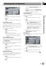

= For more details about “Selecting display or
non-display for the Mute Voice Guidance
icon”, refer to Setting the Item on the Map
Screen on page 46
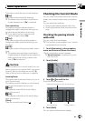
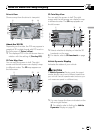
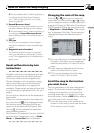
m Second Maneuver Arrow*
Indicates the turning direction after next. You
can select between display and non-display.
= For more details about “Selecting display or
non-display for Second Maneuver Arrow”,
refer to Setting the Item on the Map Screen on
page 46
n POI icon
The POI icon may appear on the enlarged
map of the intersection (when available data
exists).
o Suggested lane information*
The traveling direction screen is displayed
when you approach a interchange, junction,
or exit. The suggested lane is indicated with a
green arrow.
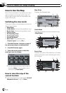
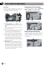
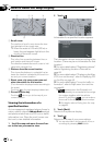
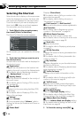
Roads without turn-by-turn
instructions
Routable roads (the route displayed and high-
lighted in purple) have only basic data and
can only be used to plot a navigable route.
Pioneer Navigation will only display a navig-
able route on the map (only the arrival gui-
dance for the destination or a waypoint is
available). Please review and obey all local traf-
fic rules along the highlighted route. (For your
safety.)
No turn-by-turn directions will be displayed on
these roads.
When your vehicle reaches to the entrance of
this road, the icon
will be displayed beside
the direction arrow, indicating that the gui-
dance is not available with this type of road.
The icon
will be indicated for roads that
have available guidance.
The Close-up of intersection function, Auto Re-
route function, Changing the view to [Guide
Mode], or [Route View] are not available.
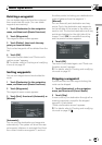
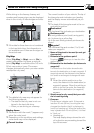
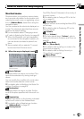
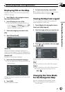
Changing the scale of the map
Touching or allows you to change the
map scale. Touch and holding
or allows
you to change the scale in smaller step within
a range of 25 yards to 1000 miles (25 meters to
2000 kilometers). When the view mode is set
to Map Mode or Guide Mode, “Direct scale
key” is displayed. Touching “Direct scale key”
changes the map to the selected scale di-
rectly.
Direct scale key
p The icon of the entry in “Address Book” and
the traffic information icon are displayed
when the map scale is 10 miles (20 km) or
lower.
p Traffic lines are displayed when the map
scale is 2.5 miles (5 km) or lower.
p POI icons are displayed when the map
scale is 0.75 mile (1 km) or lower.
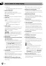
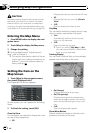
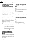
Scroll the map to the location
you want to see
Touching anywhere on the map changes the
map to “ Scroll mode” and the map begins
scrolling in the direction you touched. The
scrolling stops when you release your finger
from the screen. Pressing MAP button returns
you to the map of your surroundings.
p Touch the area close to the center of the
screen to scroll slowly; touch near the sides
of the screen to scroll quickly.
How to Read the Map Display
En
43
Chapter
04
How to Read the Map Display