


Garmin GPSMAP 695/696 Owner’s Manual
190-00919-00 Rev. F
158
Hazard Avoidance
OverviewGPS NavigationFlight PlanningHazard AvoidanceAdditional FeaturesAppendicesIndex
The GDL 39 also has a pressure altitude sensor to aid in displaying the relative
altitude of received traffic information. If the GDL 39 is used onboard a pressurized
aircraft, the pressure altitude sensor should be turned off.
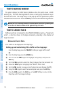
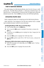
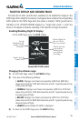
Configuring the GDL 39 for a Pressurized or Non-Pressurized
Aircraft:
1)
Press the MENU Key twice to display the Main Menu.
2)
Turn or move the FMS Joystick to highlight ‘Data Link’ and press the ENT
Key.
3)
Select the SETUP Softkey.
4)
Turn or move the FMS Joystick to select Aircraft Type (i.e., PRESSURIZED or
NOT PRESSURIZED).
5)
Press the EXIT Softkey or FMS Joystick to exit.
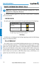
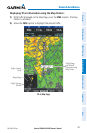
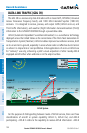
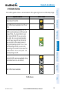
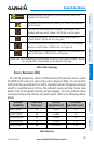
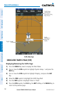
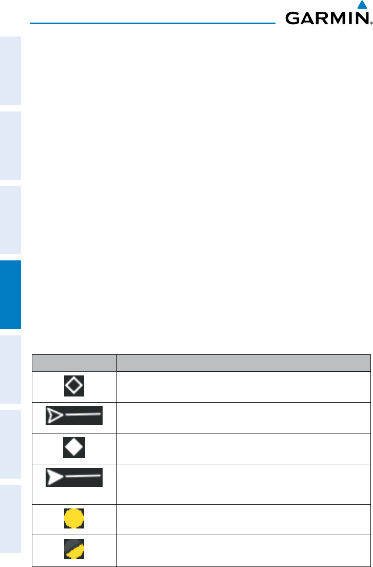
TRAFFIC DESCRIPTION
ADS-B traffic operation is similar other traffic systems, but ADS-B adds additional
symbology. The symbols used to display ADS-B traffic are shown in the table below. The
traffic identifier and altitude are displayed below the traffic symbol. A small up or down
arrow next to the traffic symbol indicates that the traffic is climbing or descending at a
rate of at least 500 feet per minute. The vector line that extends from the traffic symbol
is an indication of the intruder aircraft track.
Symbol Description
Non-threat, non-directional airborne traffic
Non-threat directional airborne Traffic with track vector. Points in the
direction of the aircraft track.
Non-directional airborne Proximity Advisory (PA). Proximity Advisories are
issued for any traffic within 6 nautical miles and +/- 1,200’.
Directional airborne Proximity Advisory (PA) with track vector. Points in the
direction of the aircraft track. Proximity Advisories are issued for any traffic
within 6 nautical miles and +/- 1,200’.
Non-directional airborne Traffic Advisory (TA)
Non-directional off-scale airborne Traffic Advisory (TA). Displayed at outer
range ring at proper bearing.