


Garmin GPSMAP 695/696 Owner’s Manual
190-00919-00 Rev. F
Appendix C
198
OverviewGPS NavigationFlight PlanningHazard AvoidanceAdditional FeaturesAppendicesIndex
nAvigAtion dAtAbAse
The GPSMAP 695/696 includes an internal navigation database that provides
location and facility information for thousands of airports, VORs, NDBs, and more.
Updates to the navigation database are available every 28 days online (www.fly.
garmin.com). There are two navigation database products available: the Jeppesen
Navigation Database, which is sourced by Jeppesen, and the US VFR Navigation
Database sourced by AeroNav Products, a division of the FAA. The update program is
designed to operate on Windows
®
-compatible PCs and requires the included USB cable
to connect your GPSMAP 695/696 to the PC’s USB port. The following information is
provided from the internal navigation database:
NOTE:
Although the Jeppesen Navigation Database and the US VFR Navigation
Database contain much of the same information, pilots may notice differences
in behavior, nearest list functionality, direct-to functionality, and map page
display due to data content variations. The US VFR Navigation Database, by
AeroNav Products, does not contain any approach data.
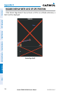
•*Airport—identier, facility name, city/state/country, latitude/longitude, eld
elevation, available fuel types, runway designations and layout, runway surface,
runway length, runway width, runway lighting, communication frequencies, and
published approaches (Jeppesen Navigation Database only).
•Weather—frequenciesassociatedwithanairport(ASOS,ATIS,andAWOS).
•*VORs—identier,facilityname,city/state/country,location(latitude/longitude),
frequency, service volume (high, low, terminal), and type (such as VOR-DME,
TACAN, and VORTAC).
•*NDBs—identier,facilityname,city/state/country,location(latitude/longitude),
and frequency.
•Intersections—identier, nearest VOR, radial and distance from nearest VOR,
location (latitude/longitude), and region/country.
•ARTCC—AirRouteTrafcControlCenters.
•Airspace—boundaries (Class B, Class C, Control Zones, SUAs, and MOAs),
controlling agency, and vertical boundaries.