


Garmin GPSMAP 695/696 Owner’s Manual
190-00919-00 Rev. F
159
Hazard Avoidance
Overview GPS Navigation Flight Planning Hazard Avoidance Additional Features Appendices Index
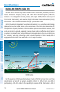
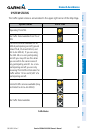
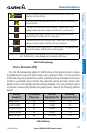
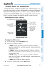
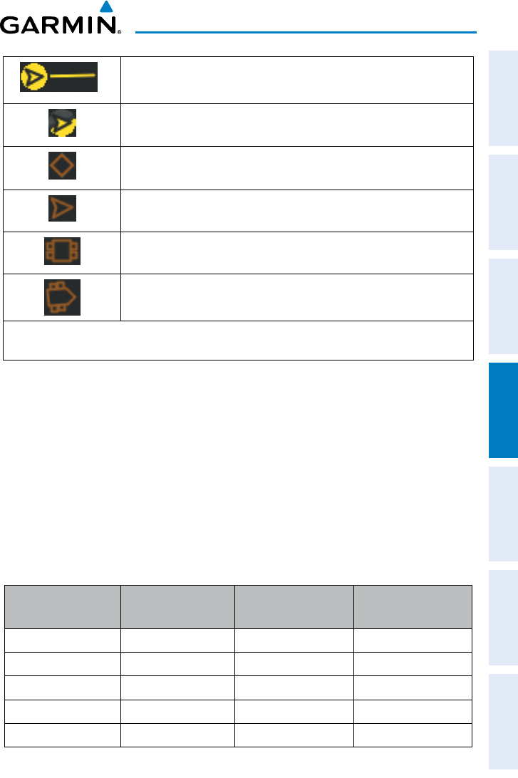
Directional airborne Traffic Advisory (TA) with track vector. Points in the
direction of the aircraft track.
Directional off-scale airborne Traffic Advisory (TA). Points in the direction of
the aircraft track.
*Ground traffic without directional information. Ground traffic is only
displayed when own aircraft is below 1,500 feet AGL or on the ground.
*Directional surface traffic. Ground traffic is only displayed when own
aircraft is below 1,500 feet AGL or on the ground.
*Non-directional non-aircraft ground traffic. Ground traffic is only displayed
when own aircraft is below 1,500 feet AGL or on the ground.
*Directional non-aircraft ground traffic. Ground traffic is only displayed when
own aircraft is below 1,500 feet AGL or on the ground.
*Ground traffic is only displayed on the Map Page when the aircraft is on the ground or below 1,500 feet
AGL. Ground traffic is always displayed on the dedicated traffic page.
ADS-B Traffic Symbology
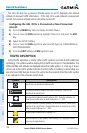
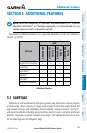
trAffic Advisories (tA)
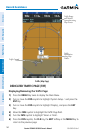
The GDL 39 automatically adjusts its Traffic Advisory (TA) sensitivity level to reduce
the likelihood of nuisance TA alerts during various phases of flight. TAs are issued for
traffic when they are predicted to be within a specified volume of airspace around your
aircraft in a specified amount of time. The protected volume and time interval varies
based on the current geodetic altitude and groundspeed. Thus, the protected volume
of airspace increases with altitude and ground speed. Refer to the following table for
details.
Altitude
(Geodetic)
Look Ahead
Time (sec.)
Vertical
Separation (ft.)
Horizontal
Separation (nm.)
Below 5,000 30 +/-850 .35
5,000-10,000 40 +/-850 .55
10,000-20,000 45 +/-850 .80
20,000-42,000 48 +/-850 1.10
Above 42,000 48 +/-1,200 1.10
Traffic Advisories