


Garmin GPSMAP 695/696 Owner’s Manual
190-00919-00 Rev. F
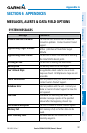
Appendix A
190
OverviewGPS NavigationFlight PlanningHazard AvoidanceAdditional FeaturesAppendicesIndex
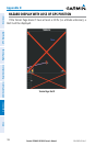
Alert
Severity
Terrain Obstacle Descent Rate
Caution
“caution, terrain”
“caution, terrain ahead”
“caution, obstacle”
“caution, obstacle
ahead”
“caution, sink rate”
Warning
“terrain ahead! pull up!”
“terrain! terrain! pull up!
pull up!”
“obstacle ahead! pull
up!”
“obstacle! obstacle!
pull up! pull up!”
“sink rate, pull up!”
“pull up!”
Aural Alerts
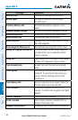
DATA FIELD OPTIONS
Data Field Option Definition
Accuracy
The current accuracy of the GPS determined
location.
Altitude
The current altitude in geometric height above
Mean Sea Level (MSL).
Battery
The current battery level.
Bearing (BRG)
The compass direction from the present position
to a destination waypoint.
Course to Steer (CTS)
The recommended direction to steer in order
to reduce cross-track error and return to the
course line.
Crosstrack Error (XTK)
The distance the aircraft is off a desired course
in either direction, left or right.
Desired Track (DTK)
The desired course between the active “from”
and “to” waypoints.
Distance (Destination) (DIST
DEST)
The distance to the destination waypoint in the
Active Flight Plan.
Distance (Next) (DIST NEXT)
The distance to the next waypoint in the Active
Flight Plan.