


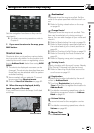

= Refer to Changing the scale of the map
on this page.
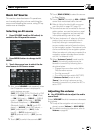
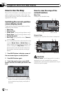
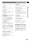
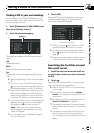
8 Map scale
The scale of the map is indicated by dis-
tance.
= Refer to Changing the scale of the map
on this page.
9 TRAFFIC icon
This appears when an XM tuner (GEX-
P10XMT, sold separately) is connected, and
traffic information is received.
a Current time
b Estimated time of arrival (or travel time
to your destination)*
The display alternates by touching it.
The estimated time of arrival is automati-
cally calculated from Average Speed set
and the actual average speed.
= For details concerning operations, refer
to Average Speed on page 81.
c Tracking mark
The tracking mark shows the route your ve-
hicle has traveled with dots.
= For details, refer to Tracking Display on
page 83.
d Map of your surroundings (Side map)
Touching the map briefly shows Shortcut
menu, while touching longer changes the
map to Scroll mode.
= For details, refer to Moving the map to
the location you want to see on the next
page.
e Distance to a turning point*
Displayed on the enlarged intersection map.
The green bar gets shorter as your vehicle
approaches a turning point.
f Next direction of travel*
When you approach a guidance point, it ap-
pears green.
g Direction line*
The direction towards your destination (or
scroll cursor) is indicated with a straight
line.
h Memory navi indicator
= Refer to About the icon for the memory
navi mode on page 160.
i Lane information*
Lane information is displayed the first time
there is a voice guidance on your route.
When the guidance screen is displayed
near an interchange or exit, the lane infor-
mation disappears.
j Freeway signs*
These show the road number and give direc-
tional information.
k Freeway exit information*
Displays the freeway exit.
p Information with the mark (*) appears only
when the route is set.
p Depending on the conditions and settings,
some items may not be displayed.
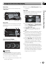
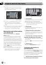
Changing the scale of the map
Touching or allows you to change the
map scale. Touch and holding
or allows
you to change the scale in smaller step within
a range of 25 yards to 1000 miles (25 meters
to 2000 kilometers). When the view mode is
set to Map View or Guide View, “Direct scale
key” is displayed. Touching “Direct scale key”
changes the map to the selected scale di-
rectly.
Navigation Menu and Map Display
En
47
Chapter
03
Navigation Menu and Map Display